


Contents
Introduction
(Updated July 2025…)
On 29th September 2024 (Edit: and continuing with subsequent 145 Alive events…), I’m hoping to venture out to take part in the event 145 Alive (visit 145 Alive’s Facebook home).
This blog documents how I researched my ideal transmitting location for the 145 Alive event, using Amateur Radio “Foundation” Licence-level knowledge of 2m/VHF propagation.
I’m discussing the free online service: https://www.heywhatsthat.com/ that helped me see the topologies (layout of the land) between various locations and my choice of Net Controller for the 145 Alive Event. The tool can be used as a free, radio Line of Sight (LOS) Surface Elevation Profile Generator (to coin a phrase).
A radio line of sight surface elevation profile generator uses surface elevation data to plot a line of sight, indicating where high things may block or distort my 2m/145MHz transmission.
Using the tool, I will be able to choose the location with a clearest line of sight between my choice of location and my Net Controller.
Please comment on this post! As you read my wanderings, learnings, and mistakes, I welcome your suggestions in the comments section (below). There’s a lot that I don’t yet understand about VHF propagation, and if you have some knowledge that would help other readers, sharing with us would be awesome 👍.
What is 145 Alive?

145 Alive – September 2024 – Planned Regions
145 Alive is a recurring event in which the United Kingdom and Ireland are divided into regions, each with its own net controller, and amateur radio operators are invited to communicate with one another through the regional controller using the 2m band (145Mhz).
145 Alive’s rationale is to make the 2m band highly active again like it once was (at least for a few hours!), encouraging use of the VHF band for amateur radio.
Bonus: 145 Alive is not a contest!
Researching a Good Location for VHF Transmission
Considerations for 145 Alive

Homebrew 2m Yagi
My amateur radio licence is Foundation level; therefore, what I think I know about getting the best out of VHF/2m transmissions includes:-
- When using the 2-meter band (VHF) I have to consider as clear a Line-of-Sight as possible between me and my transmission targets.
- I need to get up high as possible (my default QTH is 50m ASL (above sea level) and I’m the bottom of the PO7 “Grand Canyon” which, combined, is not very good.
- I’d benefit from having as little as possible blocking the path between my location and my region’s controller (buildings, mountains, etc). My net controller will be in The Trundle, Chichester.
I’ll also be limited to 10W transmission (ICOM IC-705 with no amplifier). The antenna I plan to use will be my Diamond SG-7900 vertical whip (5dB gain on 2m) and I understand that antenna gain benefits from having few obstructions over the transmission path. The antenna will be mag-mounted to my car roof, possibly with some added radials.
Elevation

Elevation – Height is Might!
Getting as high above sea level is beneficial to VHF propagation, and line-of-sight with as few things in the way is important.
To plan my location for the event, I had been recommended to use the website https://www.heywhatsthat.com/.
This is a free online service that estimates coverage and produces topography profiles between locations, along with information on specific radio frequencies may propagate.
Because I wanted to find a location that was high up and had as few “mountains” between me and other operators (that could weaken my transmissions), I was going to use the tool to visualise the topography profile between several locations.
To begin with, I wanted to plan a clear line-of-sight to the IO90 net controller at The Trundle, Chichester.
Using HeyWhatsThat.com

HeyWhatsThat.com
My Working Hypothesis for VHF:
- Choosing a location for my car, I want to “see” what might get in the way of a 2m band line-of-sight transmission between the any location I might consider and my local Net Controller in Chichester.
- Using the https://www.heywhatsthat.com/ tool, I can plot a topology graph between the two sites.
- Anything huge that is in the way between the two locations might affect a 2m band transmission.
- I would choose the location that has the fewer obstructions.
In other words, the less big stuff that’s in the way between any location and The Trundle, and the higher up I am, the better for a 2m VHF transmission.
…hypothetically!
Step by Step
Using the HeyWhatsThat.com tool:
Step 1 = Creating a Panorama.
- From the HeyWhatsThat.com home page, select: New Panorama.
- Enter the location that you will be transmitting from (accepts postcodes, Google maps plus codes etc). I tested my usual QTH in IO90LV, Butser Hill and The Churchillian Pub on Portsdown Hill.
- It might be helpful to give the panorama map a name, to refer back to later.
- Submit the location to have the tool build a new panorama view.
Step 2 = Plotting a Propagation Graph.
- Open the panorama view you’ve just built.
- Use the map to plot a line between my proposed location and the location of the controller (in my case: The Trundle, Chichester), using the Parameters section to set my band frequency to 145MHz.
- Use the map below the page to enter a destination (aka The Trundle, in my example).
- The service draws a topography profile.
Looking at the propagation graph, we can now make some decisions.
Graphical Results from HeyWhatsThat.com
I use HeyWhatsThat.com to test three locations: ✔️ Butser Hill, ✔️ Portsdown Hill, and my usual QTH: ✔️ the PO7 area.
The tool produces graphical topology images (follows) – and I have described the graph characteristics below.
Butser Hill to The Trundle
Butser Hill has a high elevation, with locations off to the the side of a quiet road to place the car, plus a car park for those who trust the gate mechanisms not to lock up (again!)
")
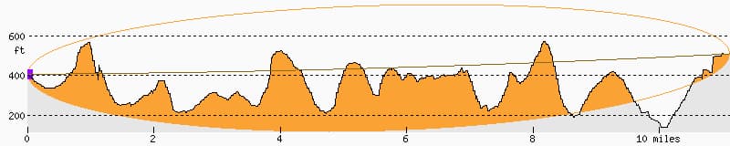
Topography profile of Butser Hill to The Trundle (Chichester)
My Usual QTH (IO90LV) to The Trundle
My home is located in the PO7 area, which is surrounded by buildings taller than I can elevate my antenna,
")
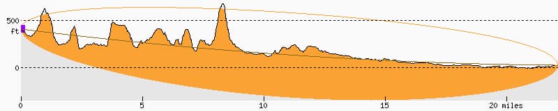
Topography profile of IO90LV to The Trundle (Chichester)
Portsdown Hill (The Churchillian) to The Trundle
Next to the Churchillian Pub is a small, quiet car park. It’s reasonably high in elevation, but with many trees around the location.
")
Topography profile of Portsdown Hill to The Trundle (Chichester)
HeyWhatsThat.com Graphing Characteristics (aka what the visual things are telling us…)
- The bottom part (the bumps) represents the terrain between the transmitter and receiver.
- The orange shaded area represents the terrain that the RF signal may encounter/bump into. The more orange, the more obstruction between the transmitter and the receiver.
- The central line represents an ideal line of sight. The more this line goes through the orange, the more obstruction the transmission may encounter.
- While some signal might diffract over the top of obstructions or refract around them, the more obstructions, the weaker and less reliable the signal, especially for FM voice.
- Although some talk of occasional atmospheric conditions (like tropospheric ducting) bending radio waves, allowing signals to travel further than normal line-of-sight, as 145 Alive is an FM / regional event (e.g. making contacts around an approx. 20+ mile radius), so such atmospheric phenomena aren’t really a factor in this situation.
Conclusions
Um – yeah, at Foundation Level, this project began as quite a bit beyond my comprehension, but… I’m learning, and VHF propagation & topology is making more sense the more I look into this.
Looking at the images, I think I can safely rule out my QTH in IO90LV; there’s quite a lot in the way, and a low elevation, suggesting I’d have a poor TX signal.
Portsdown Hill and Butser Hill look better (significantly fewer orangey bits) and fewer spikes getting in the way of the middle line, suggesting there could be less getting in the way of my transmission. But at this level of comprehension, I would have to make a big guess that being 275m ASL (above sea level) from Butser Hill could be an advantage over 100m ASL from Portsdown Hill.
Butser Hill it is then.
Darn – and I’ve just washed my car!
How did I do? Comment below 👍
Addendum to September 2024
Thank you for the following valuable comments made via different routes…
- From JN (Facebook): The orange bits of the ground that impinge into the space between the dashed line and the solid line are in the first Fresnel zone. It means that the signal may still be subject to instability, I.e. fading, but will be a good signal otherwise. The more that the ground comes into that area, the more chance of instability occurring. Also a path doesn’t need to be line-of-sight to work. There is knife edge refraction, and tropospheric ducting to consider. (ed: I’d never come across Fresnel zones before; further details to be found here: https://en.wikipedia.org/wiki/Fresnel_zone)
- DH (Facebook): Just remember wherever you go sometimes just moving a few meters can make a difference.
QSO Results (Postscript)
Well, goodness me! That turned out to be a lot of fun!!
I attended the 145 Alive event on 29th September, 2024 @ 1300 on frequency 145.300MHz/FM, Net Controller: Adrian M7EFA. I stayed for just over an hour.
Having struggled with QRM from my home for such a long while, I’d completely forgotten the possibility of experiencing clear, long-distance, 2m/FM signals!
275m ASL turned out to be an AWESOME experience! Even QSO’ing with relatively distant operators, their signal strength was sometimes weak, but the quality of their audio was always good.
So, during the event, I had placed myself atop Butser Hill (275m ASL). I made 9 contacts, a mode-average distance of 20 miles, with the longest ranges being Reading (30 miles) and Ashdown Forest (42 miles). Even the longest distances were clearly audible with very little white noise.
Yay for 2m FM !

145 Alive – M7SUX – QSO/Connections (Tool: Google Earth reading data exported from Log4OM)
July 2025 – The Second Coming
For the Summer 2025 145 Alive event (which would be my second event after discovering this approach to planning ones QTH), Butser Hill – my preferred spot – didn’t look like an option. The location was being allocated to a Net Controller, PLUS my best location from the research (above) – aka the bridlepath along South Downs Way – had been temporarily suspended (a fence had been constructed to prevent car parking while the Butser Hill car park was being upgraded – tsk! 🤦).
So, I was considering looking for a location a little closer to home this time. A problem with my home location is that (a) it’s not very high, (b) many outdoor places are surrounded by high trees and (c) I’m in a big dip. A collection of things that (theoretically) make FM/2m transmissions difficult.
I wanted a couple of options – preferable secluded because I was hoping to set up a 10m pole with a Diamond X50 on top. A serious overkill for my 1w transceiver, but I prefer some privacy while experimenting!
Initially, I researched four locations I felt comfortable operating from: two along Portsdown Hill Road and two where I like to do POTA (HF) experimentation at sea level. Each location added to HeyWhatsThat.com is given The Trundle, Chichester, as the destination.
Here are those graphs.
Nelson’s Monument
Nelson’s Monument (Monument Lane) has a reputation for being a decent VHF point.

Nelson’s Monument to The Trundle
“Gosport View”
Gosport View is a parking bay off the main Portsdown Hill Road just past Fort Southwick.
 to The Trundle")
PO17 (“Gosport View”) to The Trundle
Hayling Island
Hayling Island is effectively at sea level (0m ASL). My area’s Net Controllers tend to go for higher ground.

Hayling Island to Trundle
Broadmarsh Coastal Park
Broadmarsh Coastal Park is also at sea level (0m ASL). Its location is a few miles west of Hayling Island.

Broadmarsh Coastal Park to The Trundle
All in all, not ideal (line of sight-wise, and seclusion).
The day before the event, and quite by accident, I discovered a location on the way home from Butser Hill (IO90lw). A public (free!) car park that was reasonably secluded, ideal for experimentation, at 130m ASL. HeyWhatsThat gave the following feedback on the location:
Clanfield
Peel Car Park to The Trundle
So, theoretically, still a bit meh, but the location felt safe to try!
July 2025 Report
A really wet day. A windy day. Very few participants (around 8 over the space of 90 minutes – three of whom I could hear).
The experimentation was worth the three QSOs made.
It took me around 30 minutes to piece together the Diamond X50 antenna atop my “heavy duty” telescopic pole. With the wind being around 12 mph (30mph gusts) I was not confident of extending the antenna the full 9m; settling for around 5m instead. Even so, having never applied guy ropes to poles and so didn’t this time neither, I was concerned for the pole snapping with the sudden bends it would make during the mild wind gusts. In the end, the pole survived, and the antenna performed 100% better than the Diamond SG7900 – the antenna I had used previously, – magmounted to my car roof, but making transmissions that others could not hear from my location.
Firstly, the radio report for IO90LW to The Trundle was “a booming” 5 by 9, and I gave the same report to Adrian M7EFA (me: 130m ASL, Adrian 11 miles away at 200m ASL).
Some people to my east, barely a few metres above sea level, could not hear me (0/0) whilst I could hear them very clearly (5/7). Those towards the east of me could hear me, I believe those to the west could not. Interesting experiences for a small data set – just 8 people taking part.
After the net controller moved from facing north to facing south, I could not hear the controller any longer – and the skies were falling on my car like buckets of water being thrown at me, and the “heavy duty” pole waggling like it could snap any moment, I’d had enough!
The three contacts gained (5/9 all three) are mapped as follows:

… and just to prove the point that tools are useful, but they’re not the be-all-and-end-all, here are HeyWhatsThat.com graphs* from my location to each QSO’s location (remembering that each operator gave me a 5/9 or 5/8 report):
*Click image for larger version.
M7EFA / IO90OV

IO90LW to IO90OV
M7HQJ / IO90QX

IO90LW to IO90QX
G5KUE / IO90RT
IO90LW to IO90RT
Conclusion (to July 2025’s Event)
In conclusion… one can use tools to analyse the data until one ends up spinning in a circle (I cleaned up the expression I was going to use).
The tool, HeyWhatsThat.com, is a useful one – but I’d suggest using it as a suggestion.
The orange parts representing the TX from my chosen location to The Trundle suggest that I would not be heard very well at all. Reality was very much not the case.
Of course, the tool gives us sopme knowledge – whether there’s nothing but mountains (or, as one Welsh operator put it; “sheep on stilts”) between one’s QTH and a Net Controller. But if the map graph isn’t anything like full-on orange, just go out and try the location anyway.
Experiment!
Play!
Have Fun!
Dean M7SUX


Very nice clear, structured and illustrated How To Dean. Can see a lot of amateurs using this as a handy reference.